The Flower Fed Buffalo
The flower-fed buffaloes of the spring
In the days of long ago,
Ranged where the locomotives sing
And the prarie flowers lie low:
The tossing, blooming, perfumed grass
Is swept away by wheat,
Wheels and wheels and wheels spin by
In the spring that still is sweet.
But the flower-fed buffaloes of the spring
Left us long ago,
They gore no more, they bellow no more:--
With the Blackfeet lying low,
With the Pawnee lying low.
- Vachel Lindsay


Tuesday, 7 August 2012

The Rockies - Part 2

A Climb, Two Walks and Recovery in Calgary

Unfortunately we haven't had very regular access to the internet, so I've fallen behind. My apologies but I hope that this instalment will be worth waiting for. I'll still be behind, but c'est la vie!

Joy

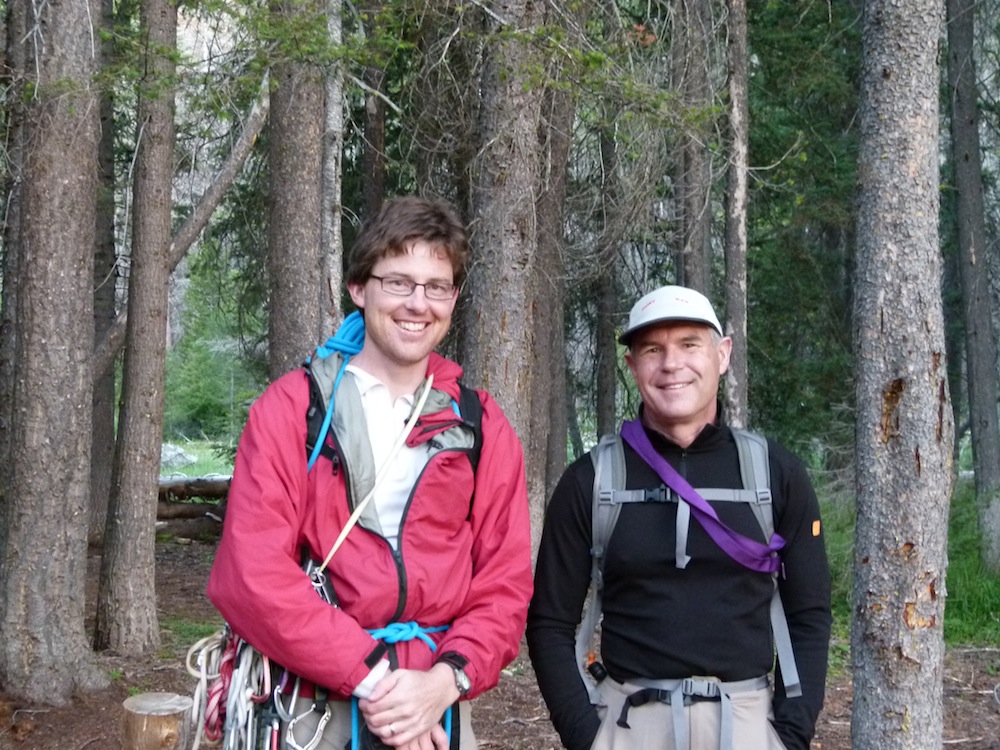
A climb that we had earmarked before we left home was Joy on Mount Indefatigable. Deep in Kananaskis Country in a beautiful setting, Joy's line is an irresistible magnet: once you've seen a picture of it you want to do it.

Finally, the day arrived for us to have a go at this long-anticipated adventure. Knowing we had a long drive, we were up early. Here is the route from Canmore to the Interlaken Car Park between Upper and Lower Kananskis Lakes:


It's about a 75 km drive, almost all on dirt roads which are fortunately in pretty good shape. Big Blue is still cruising along nicely (we've done about 6500 mms together since we hitched up). There was a bit of mist hanging around Spray Lakes early on:


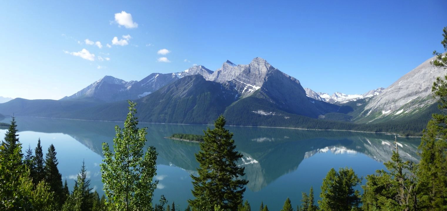
A little further down the road the sky was clear and we could see more of the mountains:


We were really lucky to have such a beautiful day for a long outing. Our approach involved walking along the lakeshore for a bit before slogging up steep scree to the bottom of the climb. Here’s Di looking nice and chirpy only minutes after leaving the car:


As we started up that slogging scree slope we were delighted to be serenaded by a loon on the lake. If you have your sound turned right up you should be able to hear its haunting cry:


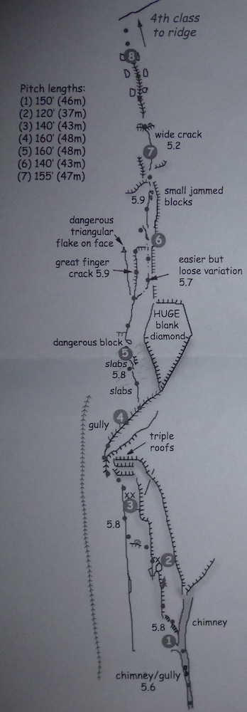
Early on the way up the scree the view of the route looks like this, with the rough line of our approach and the route drawn in:


As you can see, the slab is quite low angled and was very quick to climb.

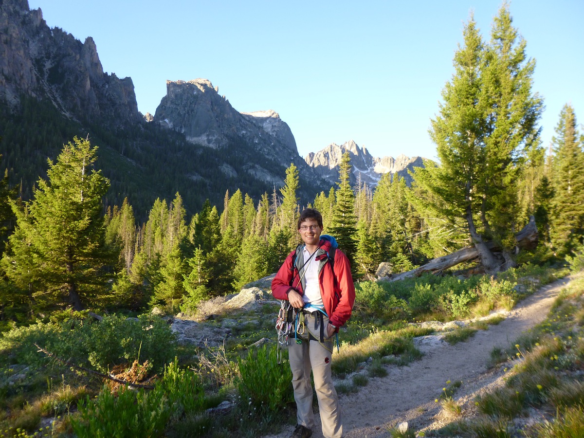
The view from the base of the climb made a nice excuse to stop and catch our breath before starting climbing:


Soon we were busy on the route itself. Essentially a long slab climb up a beautiful wispy corner feature, Joy is a classic of the Rockies. Here’s Di a long way below me about halfway up the route (the circle should make it easier to see her - these are loooong pitches!):


And here she is getting closer to the belay:


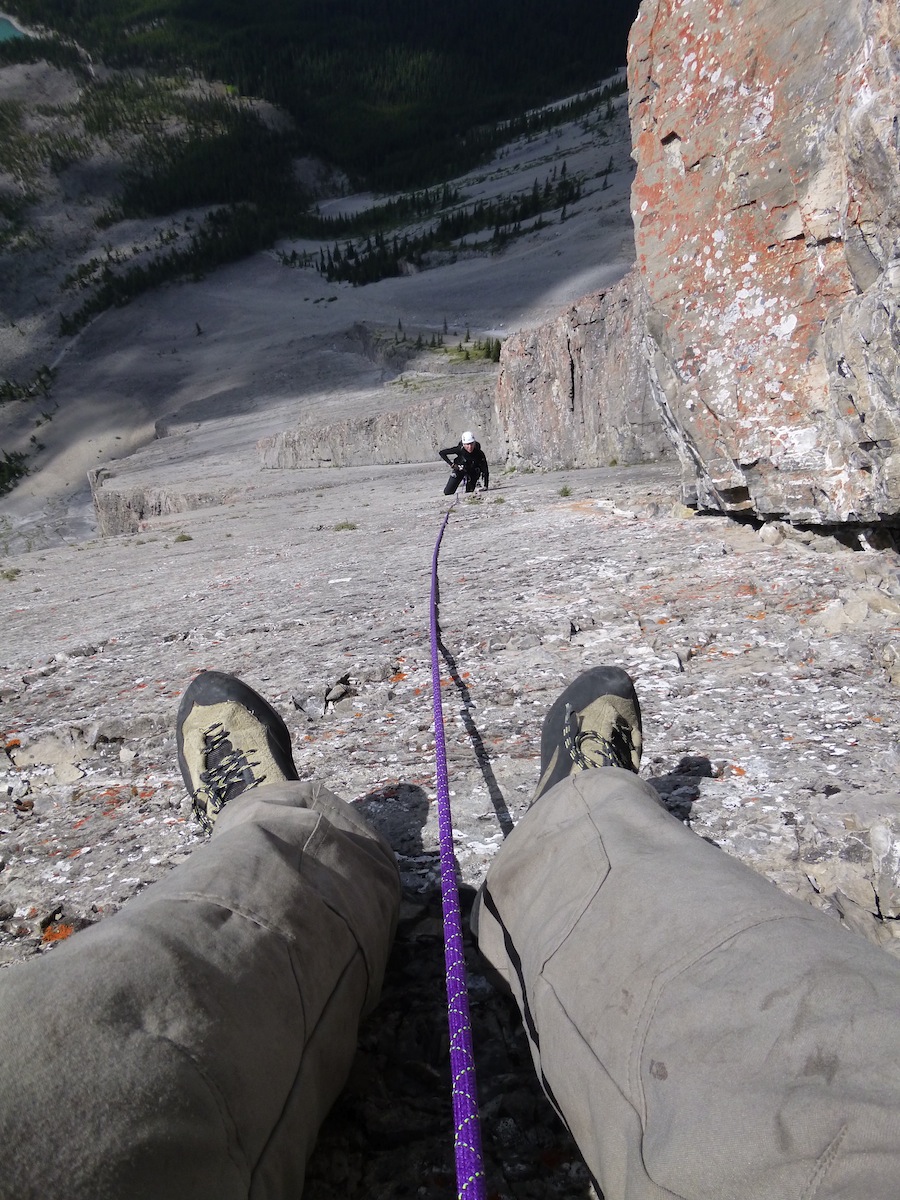
Further up the route, here’s Di looking ahead at options. She will break out of the corner on to the slab shortly. At this point we are getting well into the climb:


Once at the top of the route, there was an easy scramble over broken terrain, then some traversing across steep alpine meadows to the popular walking track to the top of Mt Indefatigable. The meadows were laced with Forget-Me-Nots:


It was a long way back down the track to the car park and when we got there we were very pleased to cool our feet in the lake. We pulled up pretty well after our 7 hour day out, which is about right in the middle of the expected time for the outing:


Not bad for a couple of old duffers, eh!

Sunshine Meadows

The evening after we climbed Joy we had arranged to meet our friends Konrad and Izabela at Tunnel Mountain to camp together overnight. It was so good to see them again after a seven year gap, but we were careful not to celebrate too much as we had arranged to meet their son Greg and his girlfriend Cassandra by 9:00 a.m. the next morning in the car park for Sunshine Village (one of the most scenic ski areas you will find in North America). In the summer Sunshine Village transforms itself into Sunshine Meadows, an amazing and extensive area of boundless wildflowers, and you can either walk the 7 kms up the road and back down or pay for a shuttle. We thought that it was better to  spend our time exploring the meadows so we opted for the shuttle. Greg texted Izabela to let us know that he'd be there in time for the 10:00 a.m. shuttle (Greg and Cassandra like their sleep-ins on the weekends!) so we had an hour up at the village with Konrad and Izabela to relax and let the day warm up before starting our walk. It was worth the wait. Despite there being mixed sun and clouds the views of the wildflowers and of the surrounding mountains were wonderful.

Here's a low angle view of some Paintbrush with an Anemone gone to seed peeking in from the side:


Despite the overcast conditions, a wider view shows just how thickly carpeted the meadow:


Sunshine straddles the Great Divide and therefore is partly in Alberta and partly in British Columbia. It's no wonder the views are so panoramic:


On a clear day you can see Mount Assiniboine - known as the "Matterhorn of the Rockies" from various points in the Sunshine ski/walk area, especially the higher peaks. When we had our year off in 1992 we had a day skiing at Sunshine and were blessed with such wonderful views of Mt Assiniboine we subsequently spent a week ski touring in the area.  Unfortunately, on this day, or most of our walk the peak was obscured by cloud but we did get a glimpse just as we were finishing.

At our lunch stop this persistent Columbia Ground Squirrel kept trying to coax food from us ...


... but we resisted with determination as it's both illegal to feed the animals and bad for them.

Although Greg has been dragged along on outdoor adventures with his parents since he was a little tacker, Cassandra has not done much hiking. As you can see from this photo, Greg is no longer a little tacker and Cassandra seemed to enjoy the day out immensely:


We first met Greg in 1992 when he was about six, and it was fantastic to catch up with him again and to meet his lovely partner Cassandra.

Here's another photo of us with Greg's proud parents:


Further along the walk we were treated to yet another lovely panoramic view. You will notice how extensive the meadows are, but this is just a very small fraction of them:


Because of the height and therefore the cooler temperatures of Sunshine Meadows there were lots of Anemones still in flower:


Close to the end of our walk was this much-photographed view of Rock Island Lake:


One thing that really struck us was how widespread were the wild strawberries. In many places they grew thickly alongside the track. Unfortunately it was still too early in the season for them to be ready to eat as most were still in flower or just in the earliest stages of setting fruit ...


... but if you visited the area in mid to late August you might get a feed if the squirrels, marmots and bears didn't beat you to it!

After our terrific day out together, Greg and Cassandra drove home to Airdrie while the rest of us returned to Tunnel Mountain for a little more libation than the previous evening.

Windy Peak

Iza and Konrad had picked a walk overlooking Canmore for us to enjoy the following day.  Luckily for us it was one of the few short walks between Calgary and Banff that they hadn't already explored, mostly because it's recommended that you visit in a party of four or more due to frequent bear activity in the area. Di made sure that she had our bear spray with her, and Konrad and Iza brought both their bear spray and their bear banger with them. (Di, ever alert for a bear deterrent, showed great interest in this little device and subsequently purchased one when we went into Calgary).

It was a fantastic day out. Better weather than the previous day and, perhaps because of the lower elevation, although the alpine meadows we traversed weren't as extensive as at Sunshine, there seemed to be a greater variety of flowers in bloom. On the way up we had this view of Mt Lougheed on the left and our little objective on the right:


 I might just let the flowers speak for themselves:
Old Man's Whiskers seed head
Mountain Fleabane

Brown-Eyed Susan
White Camas
Wildflower Bouquet
Western Canada Wood Lily


On the track up we passed this leaning tree, which is a pretty good indication of the prevailing wind direction:


At the top of the peak the Geodetic Survey of Canada had placed this marker ...


... and while I was relaxing and enjoying the view this moth lighted on my arm momentarily:


Of greater interest though was the marmot that Di photographed:


We enjoyed a great, leisurely lunch then began the walk down the hill. Everything was just bursting with life, as is attested by the crop of healthy pine cones atop this tree, just like a lot of Christmas tree decorations:


Small, but perfectly formed:


The only downer for the day were the mozzies, which were voracious! Numerous applications of repellant hardly deterred them: the only solution was to move fast. Luckily, they don't seem to cause too much of a reaction so any swelling we did get was fairly minor and disappeared quickly without too much itching. 

Into Calgary

When we got back to the car park we followed Konrad and Iza back to their place in the northern part of Southwest Calgary, which is very quick and convenient to all roads leading west to the mountains, which is why they have settled where they have. It was fantastic to get a real shower and enjoy a bed a bit bigger - well, truth be told, a lot bigger - than what Big Blue gives us. Konrad and Iza had arranged for us to go out for sushi with Greg and Cassandra on Monday and insisted on us staying two nights. 

Two nights in a real bed! Luxury! We managed to catch up on all our laundry, stock Big Blue with groceries, and I did some blogging. Sushi at Globefish on Monday was fantastic  then Konrad showed us some slides from a trip that they had done into Mount Robson, the highest peak in the Canadian Rockies. They were stunning images, and I tried to convince Di that we could do a day trip to Berg Lake for the views but she wasn't biting. She'd made her mind up that a 42 km return trip with a lot of elevation gain wasn't in the best interests of matrimonial harmony. I guess she's probably right, but that's another story.
As ever, Konrad and Iza's hospitality was wonderful, but the mountains awaited our return. On the way out of town we stopped at the candy store again so that Di could buy herself a new harness because the one she'd been wearing was - literally - a pain in the butt, and a new pair of climbing shoes for all day comfort to replace her faithful old Boreal Aces. It looks like she's not giving up climbing yet ... YAY!


Thursday, 2 August 2012

The Rockies - Part I

Going to the Ghost

So, here we are in the heart of the Rockies: Canmore, Alberta. It's been nine days since my last post and we've been reasonably active. However, before detailing some of our recent escapades I want to show you an early impression of arriving in the Rockies which should really have been in the last instalment. We came into Canada via Highway 93, which involves driving up the Kootenay River and then crossing the Continental Divide just north of Banff. The views as you drive north are a teaser of the majesty ahead. This picture of the Kootenay River flowing under the western ramparts of the Rockies will give you an idea of what I am on about:


As detailed in the last blog, we rolled through the Rockies and into Calgary, where we stayed with Jon and Di for a couple of days. This post is all about our trip into the  Ghost River wilderness for a bit of climbing. Luckily for us, Jon had arranged for his good friend Andy  Genereux - the author of the Ghost River climbing guidebook - to show us around and point us at some things. Andy suggested we head out the morning he got off from his latest shift with the Calgary Fire department, so we rolled over to his place and hit the road at about 8:30. It was a quick exit from the city and soon we were on the highway heading north and then west.

I just love the way some of the roads in and around Calgary are called "trails", which seems to hearken back to pioneer days. Here, we are looking out the window of Big Blue at the Crowchild and Stoney Trails, with Andy and Jon disappearing out of sight in Andy's (fire engine red) truck:


Big Blue managed to find an extra gear to catch up and before long we had arrived in the Ghost and settled into this fantastic campsite:


Once we had Big Blue levelled up and Jon had his tent pitch, we all piled into Andy's truck, descended to the river flats and drove a few kilometres up the valley to the day's chosen crag. Andy had picked out the classic six pitch 5.8 trad route "Bonanza" for Di and me, while he and Jon would do something a little harder to the left, finishing up at the same final ledge.

Jon refers to Andy as "The Incredible Talking Guidebook" due to his ability to seemingly remember every move on every climb he's ever done. Here he is telling us about the delicate step back right on the traversing fourth pitch, while we can only gape (as you can clearly see) with amazement at Andy's ability to identify and describe such fine detail from so far away:


The photo below shows roughly the line of our climb (the yellow dashes indicate the route is out of view in the chimney that comprises the first pitch):


Di, being the chimney aficionado in our climbing team led the first pitch:


And here's a photo of us at the top anchors:


As you can tell from the way we are dressed, it was a bit cool. It actually showered just a little, but this didn't last and we enjoyed the views while waiting for Andy and Jon to arrive at the top rappel station ...


... and here they are, two living legends of the Rockies climbing scene:


On a more down to earth note, right beside where Di and I were clipped in to our top anchor was this lovely patch of lichen:


Upon returning to ground level we were all happy to call it a day, so we headed back to camp for some dinner and to enjoy some of Andy's tall tales of roped soloing many of his first ascents in The Ghost.

The next morning before breakfast Jon got this lovely photo before we headed off the the crag:


Di had a bit of a sleep in while Andy made his own special version of Huevos Rancheros for the rest of us. (No picture; too busy eating and trading lies!).

Once Di roused herself we set off for some more climbing. Andy had earmarked another great route for Di and me to jump on, a four pitch 5.10d sport climb called "Magic Carpet Ride" while he and Jon did some single pitch stuff. Here's Di on the slabby 5.9 first pitch of our route:


(We are headed up and right of the big roofs just about Di).  And here's a bit of a bum shot of me just after the crux on the  second pitch:


All went well and we were soon back at ground level. All the way up our route there had been thunderstorm activity to the north and south of us which Jon described as a "pincer movement on the part of the weather gods". There was a great looking feature just to the left of the route that Di and I had just climbed. Another first ascent of Andy's as it turned out, which he'd called "Burning Arete" after doing it during a big fire in the area. It was a very engrossing mixed route which I got to the top just as some big, fat drops started to fall out of the sky. Jon cleaned the pitch as the rain increased and then we skedaddled back to the car, unfortunately not quite escaping a heavy shower.  Maybe if I hadn't stopped to snap this photo of the beautiful trail that Andy has made up to the crag we wouldn't have got quite so wet, but I couldn't resist:


 As we drove back to camp we couldn't help but notice how wet the road was, how full all the potholes were, how soaked Jon and Andy's tents were, and marvelled at how lucky we had been to escape getting an absolute soaking while out on the rock. 
We spent a bit of time having a coffee, eating cookies and telling more lies before packing up and heading off: Andy and Jon back to Calgary and Di and I on to Canmore.

Andy's surname should really be "Generous" not "Genereux", as that is his nature. He was very keen to share his love of "The Ghost" with us, and we appreciate him spending a couple of precious days off in between shifts to show us around his backyard. Thanks, Andy!

Tuesday, 24 July 2012

Travelling North

Almo to Stanley: featuring the Pioneer Saloon in Ketchum

It goes against the grain to retrace one's steps on a road trip - a circuit seems so much more interesting somehow. Nevertheless, that's what we've done. More about the why in a moment.

As it turned out, our last day at City of Rocks was clear and sunny and not too hot, so we decided to do a couple of routes before heading for the highway, which seemed to add a final touch to our stay there.

Next stop was Burley, where we gave Big Blue a much-deserved oil change at Walmart. While that was happening we wandered around looking for a new bucket. I found a new camera instead!
On then to the town of Bellevue to do the washing, where we also had a fantastic late lunch. and then a stop in Hailey to have a little repair job done on Big Blue's wind-out windows. He's such a big softie, really. Every once in a while he just needs us to show him we still love him. There are some small tracks that a little sliding cleat runs back and forth in, and a couple of them needed to pop-riveted back in place. A quick little repair we could have done ourselves had we the right tools.

Then on to the wonderful fun-hogs paradise of Ketchum to restock our cupboards, which were getting a bit bare, and have an evening meal. (I'd forgotten that I had a date with my darling wife, but managed to catch on eventually). There is a fantastic supermarket in Ketchum called "Atkinson's". We stocked up on the goodies, then wandered up and down a bit looking for a restaurant. After asking if we liked steak, and getting an answer in the affirmative, some locals suggested the iconic Pioneer Saloon. The steak was great, and the company fantastic. We got talking to a couple of guys at the table next to us and ended up sharing a bottle of Oregon Pinot Noir with them.

The decor in the Pioneer reflects its historic heritage and frontier location with a bison's head mounted near the door:


This picture with Di alongside the bison gives an indication of its size:


There is a moose nearby to keep the bison company: 


There was lots of other wildlife adorning the walls, and a myriad of interesting artefacts. However, my favourite touch was the illustrated basin in the gents' toilet:


After dinner we cruised a few miles north of Ketchum, pulled off the road into a little car park at the start of a hiking and mountain biking trail, pulled the curtains and settled in for some kip.

The reason we decided to retrace our steps was that, while we were at City of Rocks, Di had suggested I contact Matt Church, a guy we'd met while hiking at Mt Rufus six months ago, to see if he'd like to do the Mountaineers Route on the Elephant's Perch near Stanley with me. Matt and his wife Anastasia live in Moscow (Idaho, that is) and to my delight he leapt at the chance to do this iconic climb.

The next day we motored off to Stanley to meet with Matt and Anastasia. They were held up with roadworks and had forgotten that Idaho has two time zones (it's a long story!) so arrived a little late, but we were able to get organised in time to catch a boat up Redfish Lake with them to camp overnight.  It was a lovely evening despite the mozzies and we hung out with Nikko, Matt and Anastasia's dog for a while ...


... before getting into tents to get away from said mozzies! 

The Mountaineers Route

We made a reasonably early start the next morning for what is described as a two hour approach:


This little map shows the approach to the Elephant's Perch from the end of Redfish Lake:


Here is a topo of the Mountaineers Route from North American Classic Climbs:


We saw a  couple of deer along the trail a few minutes out of camp, then I took this photo of Matt when we reached a clearing and had our first clear view of where we were headed (the Elephant's Perch is the cliff line you can see above Matt's head):


Before we knew it we were at the rickety log crossing ...


... and nearing the Elephant's Perch ...


There was still a bit of snow along the trail at the base of the crag where the sun got but a short time to do his magic:


Here's another view of this magnificent piece of rock from almost directly below the route. Note the famous huge blank diamond that defines the Elephant's Perch:


Here's another picture with the first five (of eight) pitches drawn in:


The previous two pictures have been overexposed a little so that the detail of the cliff would show a bit better, but my favourite shot is this one which is more representative of the natural light as we walked under the crag:


We got started on the route almost two hours exactly after leaving camp at Redfish Lake. Pitch 1 was up a chimney/gully with one move of about 14 (5.6 in American speak):


Matt led the second pitch ...


... and I scrambled up behind him:


Pitch 3 took us up a corner/crack, out to another crack ...


and then back into the corner again:


The view was starting to get pretty good:


The iconic, but surprisingly easy "Triple Roofs" were next:


Matt took this pretty neat "vertical panorama" from the belay on pitch 4:


Pitch 5 involved a 5.8 move across and up a slab and then a series of easy but fun ledges ...


Pitch 6 took us up some nice cracks and corners ...


... and finally we were above the wonderful diamond-shaped bit of rock that defines the left side of the Elephant's Perch:


The crux of the route is pitch 7, and involves a really nice bit of jamming where the rock steepens up a bit ...


... and then eases off again:


The last pitch was easier and then we were at the top:


The view back down Redfish Lake Creek and beyond was pretty good ...


... but towards the head of the cirque was brilliant ...


We had a rising traverse to get across to the descent gully ...


... where we enjoyed fantastic views of Saddleback Lakes:


Matt set up the rappel at the bottom of the gully that would take us back to ground level ...


... and I followed him down:


After having heard about this route decades ago and dreamed about doing it some day, it was fantastic to get on it and experience what all the hype is about. Interestingly enough, we found the first four pitches were all a bit shorter than the description in the topo, so the route overall must be a bit shorter than the 1000+ feet it is supposed to be. More like about 900, but great climbing on (mostly) wonderful rock. If you're paying attention to what your doing - i.e. staying away from any big loose stuff there is little objective danger. Highly recommended!

Barren Pass Hike

While Matt and I were climbing, Di, Anastasia and Nikko (Matt and Anastasia's dog) had a hike.  Di took a couple of nice panoramas:


She liked this flowering shrub:


She got a bit warm on the walk up to the pass:


Anastasia and Nikko did too, so they kicked back for a bit:


Eventually we all rendezvoused back at the lake and got the boat back up the other end. They don't muck about:


Back to the Big Blue, off to the free camping nearby and great dinner before a well-earned rest:


Stanley to McCall; Slickrock

We made an early start the next morning, as the plan was to motor to McCall, drive up the road to Slickrock and dash up the Regular Route on Slickrock, which was the other thing that Di and I missed on our trip south. It's about 1000 feet of easy slab and crack climbing on a low angled dome. Matt was keen to join us and Anastasia thought she'd have another hike, so that's just what we did.

As predicted by the fishermen we'd seen a couple of weeks earlier, the river had dropped "a couple of feet", making the crossing nice and easy. Note the clarity of the water:


It was a bit of a hike up to the base of the route, with some nice flowers along the way. Can anyone identify this for us?


We were nearly at the base when I took this photo:


In case you missed the reason for the previous photo, we've got to have Big Blue in each post:


Here's a photo of Di taken about a third of the way up the route:


A bit higher up, this amazing rock arch caught my attention:


We didn't stop much for photos, and were soon at the top:


We spent the night camped just about a mile away at another great free camping site, then drove north to Moscow to spend the night with Matt and Anastasia. The real treat was to visit their Saturday morning Farmers Market, which was fantastic and very much like the Salamanca Market in Hobart was  20 years ago (before it got bigger than Ben Hur and is now, in my humble opinion, not worth visiting).

A day and a half of leisurely driving brought us to the Rockies where another amazing coincidence has occurred. We stopped in at the Tunnel Mountain Campground in Banff to see about booking a camping site to share with some friends from Calgary. At the kiosk we started chatting with one of the parks personnel who turned out to be Steven Gale, the son of our friend John from Launceston, Tasmania! John, his wife Debbie and their daughter Kerryn just happened to be staying with Steve, so he invited us around to his place for a beer and to give John a bit of a surprise. And it was! We had a great couple of hours with them before getting back in Big Blue and off down the street a way to park and camp for the night.

Unfortunately, a little knock sounded on the door at 1:00 a.m. It was an officer of the Royal Canadian Mounted Police - sporting a magnificent walrus moustache - who politely informed us that we weren't allowed to camp in city limits and that we'd have to move. 

He looked a bit like this ...


... but with much more impressive facial hair, more like this but a nice brown colour:


Off we drove up Spray Lakes Road just above Steve's place, where we found a parking lot with a car and a tent beside it. This looked promising so we found a flat spot and pulled over. Thankfully the rest of the night - or should I say morning - was uneventful.

The next day we motored into Calgary and spent a couple of days with our friend Jon Jones and his wife Di, had some great R&R and spent a bit of time at the candy store.

We're looking forward to doing some climbing and hiking here in the Rockies with various friends, but that will be the next post. In the meantime, here's a summary of the distance and route north to Calgary from the City of Rocks: